Trails and Paths
Port Moody has a variety of hiking trails, bike paths, and multi-use trails that encourage you to get outside, stay active, and explore nature. Our Parks and Trails Map can help you locate the access points for all of our trails.
Alfred Howe Greenway Trail |
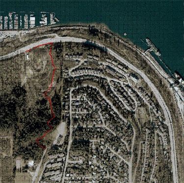
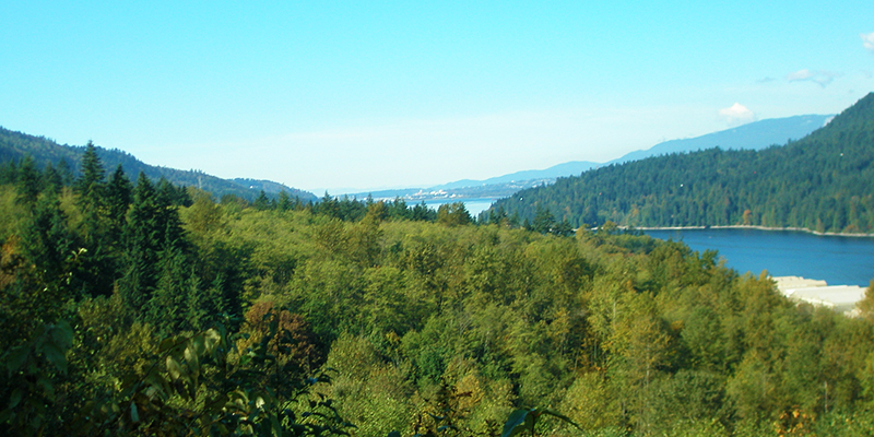
The Alfred Howe Greenway is an intermediate/difficult urban nature trail that provides a scenic connection between the Glenayre and College Park neighbourhoods and the waterfront. This gravel trail rises and falls steeply through ravines before descending the bluff of Burnaby Mountain. Stairs are located at several points alongside the gravel trail. Trail location The trail is 2.2km round trip. You can access the trail at an upper (south) access point located off the Westhill Park parking lot (203 Westhill Place) or the lower (north) access off the Barnett Highway approximately 100m west of the Reed Point Way intersection. The trail connects with the Trans-Canada Trail at Reed Point Way. About Alfred Howe Alfred Howe was Mayor of Port Moody from 1964 to 1971. During his tenure, the Port Moody Boat Launch Ramp, the Moody Street Overpass and the Centennial Library were established.
Topographical trail mapsView our topographical maps of the Alfred Howe Greenway trail to familiarize yourself with the area. |
Shoreline Trail |
The Shoreline Trail has two paths that wind along the coast of the Burrard Inlet. One is a paved multi-use path for walking, wheeling, and cycling, and the other is a gravel and boardwalk trail for walking. Please note that bicycles and scooters (human-powered or electric) are not permitted on the lower gravel and boardwalk trail.
This scenic trail starts at the pier in Rocky Point Park and ends at Old Orchard Park. It takes approximately two hours to walk the six-kilometre round-trip trail. This is a great route for the whole family with minimal elevation on either path. To check for updates on trail closures and conditions, visit our Shoreline Trail page. |
Trans Canada Trail |
The Trans Canada Trail is 24,000 kilometres in length and is the longest recreational trail in the world. The trail is made up of hundreds of local trails that join together to form one route that spans the entire country. A section of the trail passes through Port Moody. Explore the trailAccess to the Trans Canada Trail in Port Moody begins at Rocky Point Park. Follow the trail from the park, across the Moody Street overpass, along Clarke Street, to Douglas Street at Vintner Street. The trail then runs between Barnet Highway and the CP Rail tracks until it nears Reed Point Marina. At this point, you will cross the highway and go up the northeast side of Burnaby Mountain to Simon Fraser University. At the eastern edge of the Shoreline Park system, the Trans Canada Trail makes its way through the Town Centre sports fields (300 Ioco Road), behind the tennis courts and City Hall, across Knowle Street and through Pioneer Memorial Park. It then passes through Newport Village and connects with Ungless Way near Eagle Ridge Hospital and finally to Guildford Way and into Coquitlam. |
Bicycle Paths |
Port Moody offers a variety of on-and-off road bicycle routes for you to explore. Whether you're interested in cycling on roads, mountain trails, or leisurely paths, we have something for you. The Shoreline Trail offers a paved, scenic cycling route along the picturesque shores of Burrard Inlet.
The City of Port Moody is proud to co-manage mountain biking trails on Heritage Mountain with the Tri-Cities Off Road Cycling Association (TORCA). Visit torca.ca for more information about forest trails with technical trail features that are suitable for mountain biking and hiking. In the interest of public safety and to protect City infrastructure and sensitive ecological areas, any unsanctioned mountain bike trails or stunts will be immediately removed by Parks staff and the area restored to a natural condition. Please note that unauthorized trail-building activities are not permitted in Port Moody and are subject to Bylaw enforcement. See Parks and Community Facilities Rules and Regulations Bylaw (BL3321) for more information. |
Walk BC |
WalkBC has created an interactive map that includes maps and detailed descriptions for trails in communities across the province, including Port Moody. This is a great resource and can help you plan your next hike! |
Trail construction and closures
Hett Creek Trail: bridge closure
Hett Creek Trail bridge was heavily damaged during the November 2024 windstorm and in compliance with an engineering assessment the bridge section will be closed until further notice.
Trail users can detour via Wilkes Creek Trail:
In addition to providing a pedestrian pathway, this bridge is also the primary support structure for a sewage pipe that is attached underneath. Restoring the bridge will require a contractor specialized in bridge construction and stabilization to ensure it meets current design codes.
Project update, Jan 8, 2025: the process to retain the services of an independent structural engineering firm to develop a design proposal to restore the bridge is underway.
We appreciate your patience and cooperation as we complete this complex bridge restoration.
Shoreline Trail Boardwalk: partial closure to summer 2025
The section from Suter Brook Creek to the bridge over Noons Creek (Phase 2) remains closed as work continues. This phase is expected to be complete by summer 2025.
Trail users can use the upper multi-use path as a detour. For more information, visit the Shoreline Trail Boardwalk Replacement Project.